Tags : Carriageworks Central to Eveleigh Development High Rise HighRise North Eveleigh North Eveleigh Precinct skyscrapers Urban Growth
As at Feb 2016 CentralToEveleigh Webiste Content Extract.
Urban Growth Responding to Community Concerns from November Meeting. (pub. 15 Dec 2015)
Extracted for posterity in case the web-link disappears…….

Central to Eveleigh FAQ’s
Q: The Redfern, Waterloo, Eveleigh area is a dense inner city area, why are you planning high density development here?
A: Sydney needs more homes in locations close to public transport, jobs and services. We are an evolving city and we’re continually growing. Each week the population grows by 1,600 people, which means over the next 15 years we’ll need more than 650,000 new homes to support population growth. New houses must be built all over Sydney – not just in new subdivisions on the urban edges, but also in existing urban areas in the form of medium and high density development. No part of Sydney is untouched by these growth pressures.
Given its location close to public transport, education and employment the Central to Eveleigh area, like other inner city areas, is ideally suited for new housing.
We are planning for the future of Central to Eveleigh, to accommodate growth in a sustainable way. We are proposing a range of well designed medium and high rise apartment buildings and work spaces, close to improved public transport, to provide accessible and affordable living options, alongside the amenity of new well planned parks and improved community facilities.
We need to plan and manage growth to ensure the area retains its diverse and distinctive identity and remains one of Sydney’s most desirable places to live, work and visit.
Q: Will you protect social housing and provide more affordable housing in the area?
A: Yes. With our Government partners at the Department of Family and Community Services we are placing a high priority on social and affordable housing in our planning to ensure a diversity of homes to meet current and future community needs.
The Department of Family and Community Services commitment is to retain or increase social housing dwelling numbers in the area including the Waterloo Estate – this is a consistent message we have talked through with the community and local elected representatives. We are exploring opportunities to renew the social housing stock and better integrate it with affordable housing and privately owned housing. This will be a long term process – up to 20 years – allowing much time to plan the process well and time to work closely with all existing residents.
Q: There is too much development being planned, why do you want to damage the character of the area with lots of high-rise buildings?
A: We know that protecting the character and amenity of the area from inappropriate development is important and widely valued by the community.
Our focus is on making the most of opportunities to deliver new housing and jobs in a balanced way that maintains and improves the liveability of the area for new and existing residents.
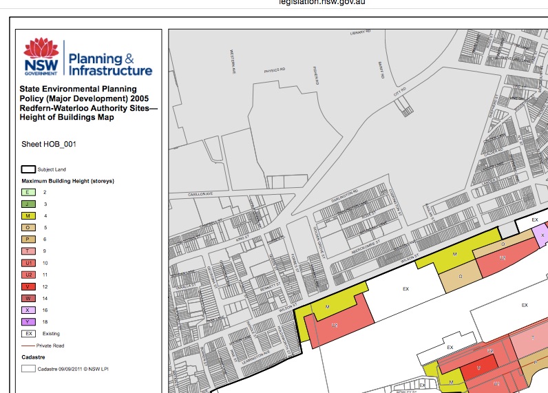
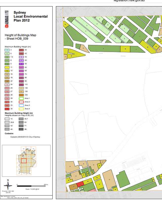
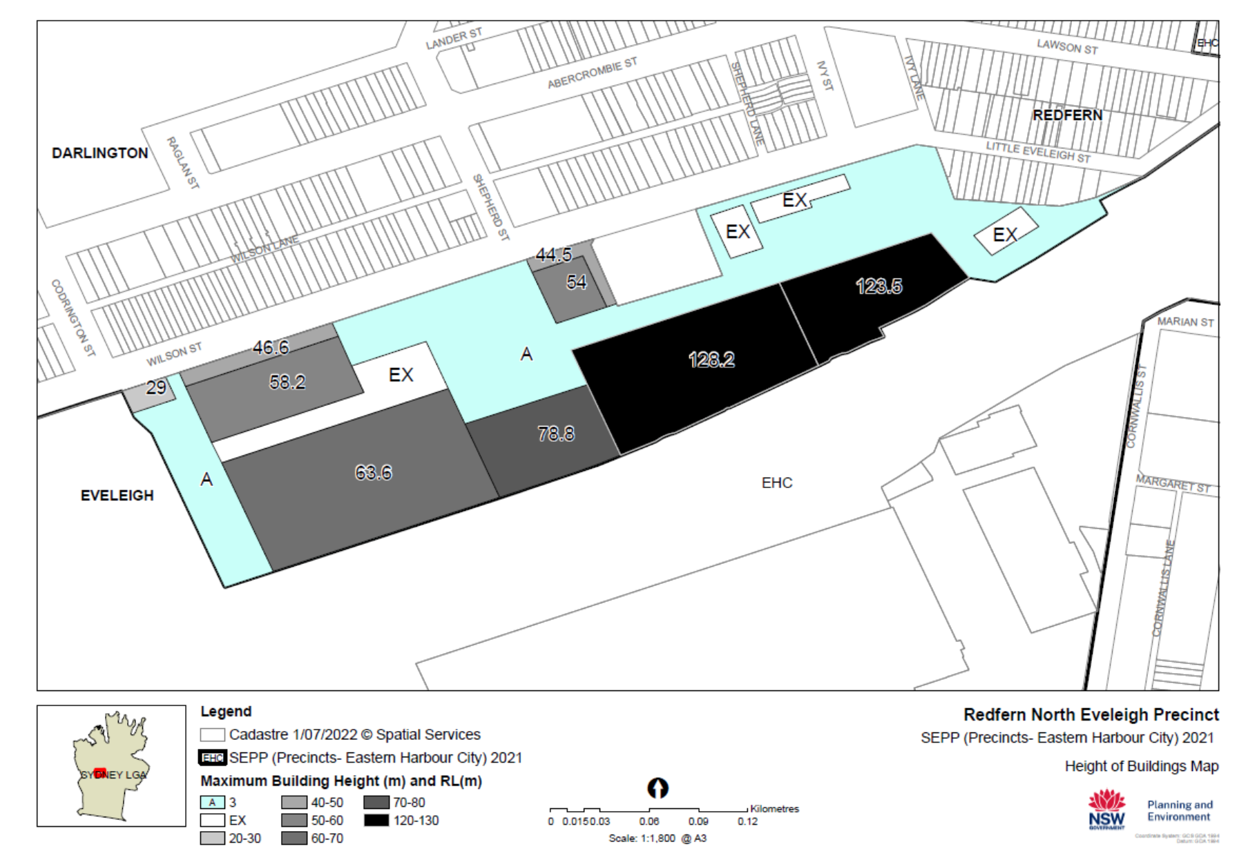
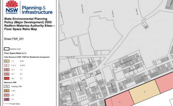
We will be considering a mix of building heights between 2-3 storeys and potentially up to 35 storeys that align with adjoining areas, for example Waterloo already has some buildings equivalent to over 30 storeys in height. There will be a need for all plans to pass strict environmental planning controls and guidelines – and a process to consult and engage with the community through this process as we have been doing. However, given the need to balance metropolitan growth pressures with local amenity impacts we believe we should consider whether tall buildings in defined locations can be built where set back from existing low rise areas can be achieved and solar impacts are limited.
Q: Will proceeds from the sale of public land all be used to fund local infrastructure upgrades?
A: Yes. The land value achieved from medium to high rise development of government land is intended to be prioritised for reinvestment in the local area to support key infrastructure requirements. As confirmed by the Minister when announcing the sale of Australian Technology Park, the revenue generated will be reinvested in the local area.
Our approach is to reinvest proceeds from the sale of public land back into the local area to help finance major infrastructure investments in the Central to Eveleigh corridor, including upgrades to train stations, new parks, restoration of heritage buildings, community facilities and to subsidise delivery of affordable housing. Redfern Station has been identified as a funding priority and we are working with our partners at Transport for NSW in this respect.
Q: How will you ensure critical infrastructure gets upgraded to support population growth?
A: We’ve been working across government to test the impact of future growth on existing infrastructure including public transport, schools, hospitals, community facilities, utilities and green space. This has helped us to identify both the limitations and opportunities for new development in the area.
The Urban Transformation Strategy will identify the key infrastructure required to support growth and will detail the long term funding requirements to deliver infrastructure upgrades.
North Eveleigh community workshop FAQs
Q: Why is North Eveleigh a good place for new housing?
A: Areas with good access to public transport that are close to employment opportunities are becoming the focus for increased density all across Sydney.
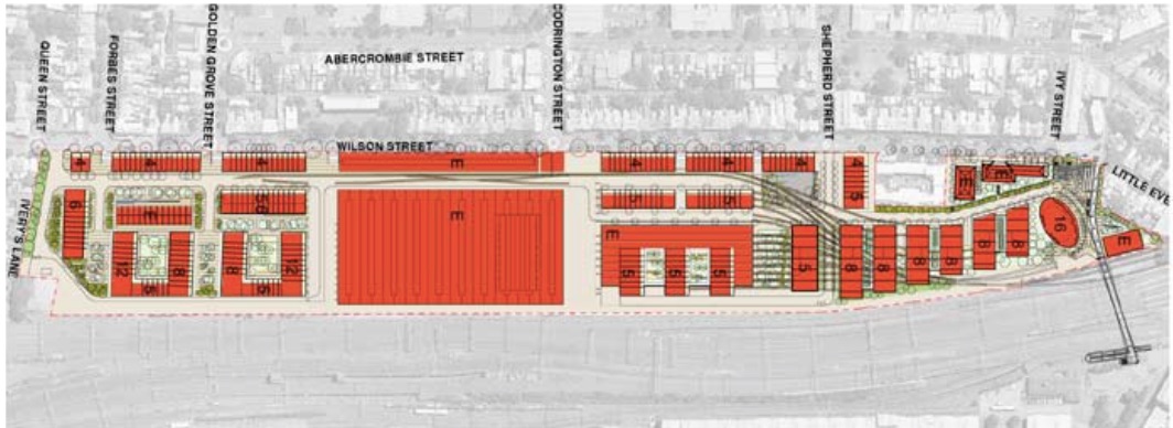
The Central to Eveleigh area, including North Eveleigh, has lots of under-utilised and government owned land and is close to the city centre, well serviced by public transport and close to many services and infrastructure, and educational and cultural facilities.
The Central to Eveleigh Urban Transformation and Transport Program will help to meet the current and future needs of residents and support Sydney’s growth as a global city by providing new community facilities and open space, a mix of new housing and employment opportunities and improved connections across the rail corridor.
Increased density also allows us to provide additional community facilities that service the wider neighbourhood. This includes large public parks and restored heritage buildings all contributing to more vibrant local communities.
Q: What makes North Eveleigh suitable for the density and height you are proposing?
A: The inner city needs more homes. We’ve been working across government to test the impact of future growth on existing infrastructure including public transport, schools, hospitals, community facilities, utilities and green space. This has helped us to identify both the limitations and opportunities for new development in the area.
It is not appropriate to have high rise development along the whole length of the Central to Eveleigh corridor because it would overshadow adjoining properties and have a detrimental impact on the amenity of the area. However, high rise buildings can be located in some areas with minimal impact. In North Eveleigh, tall buildings can be placed next to the railway with minimal overshadowing or overlooking of neighbouring properties.
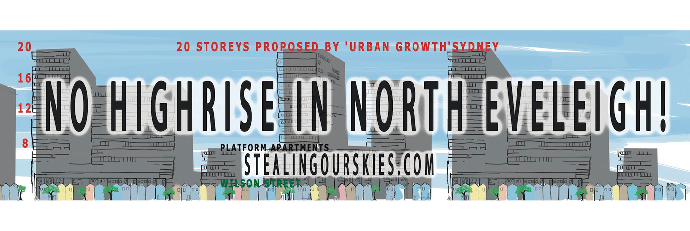
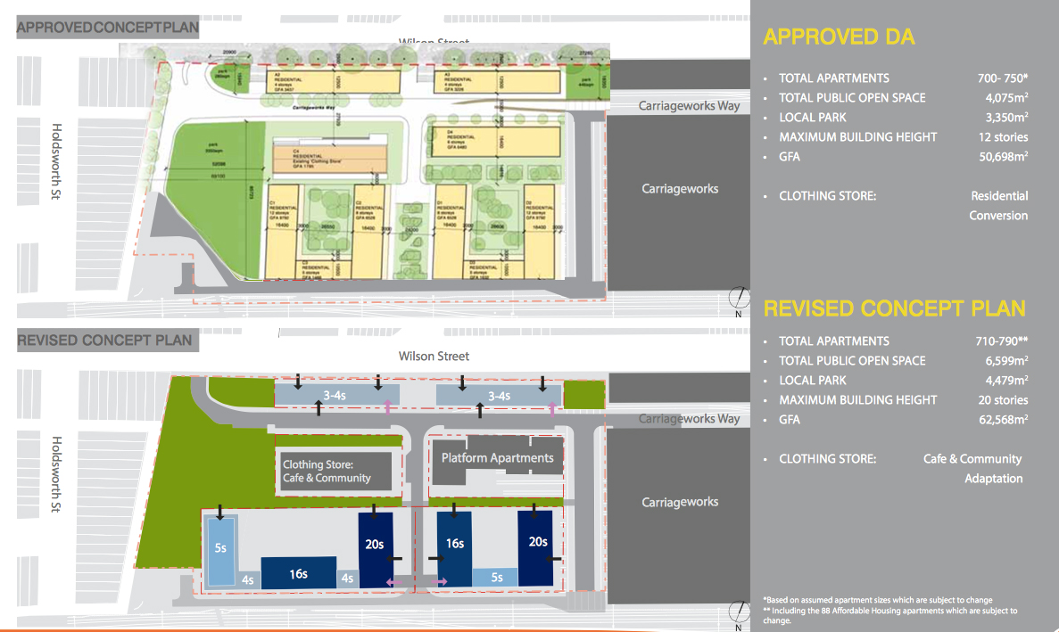
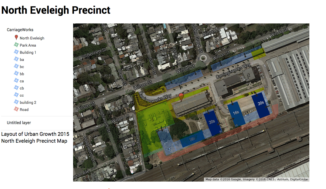
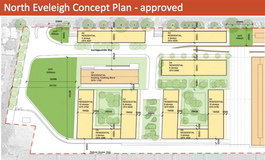
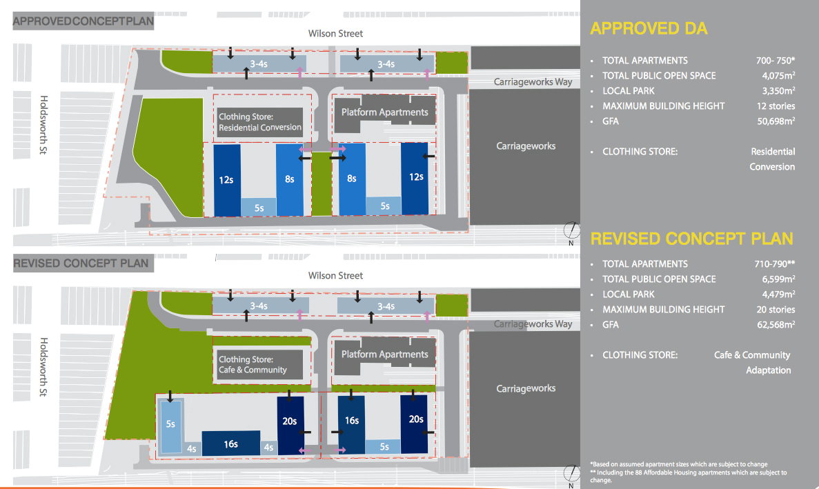
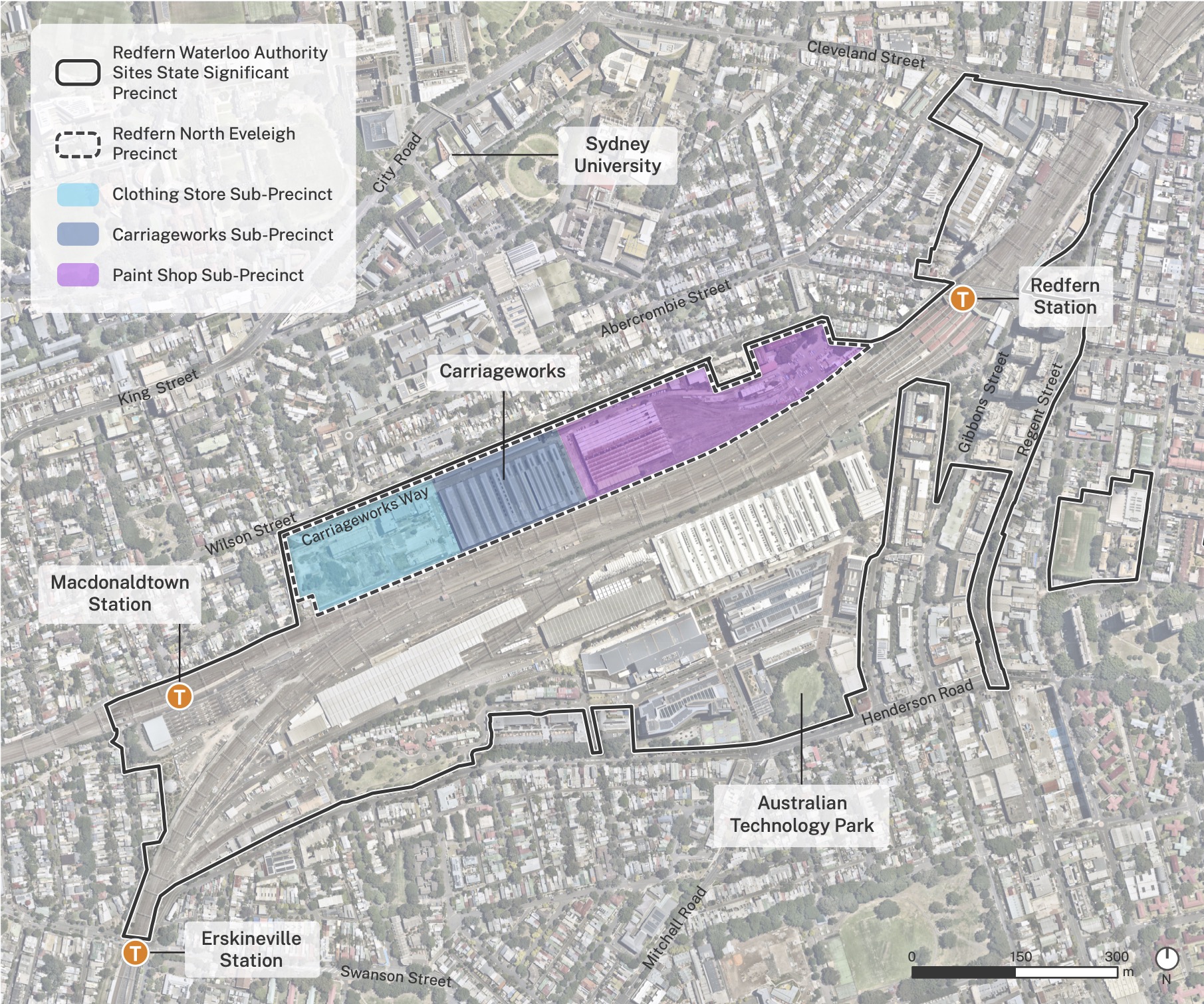
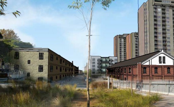
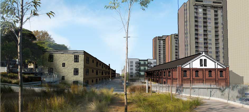
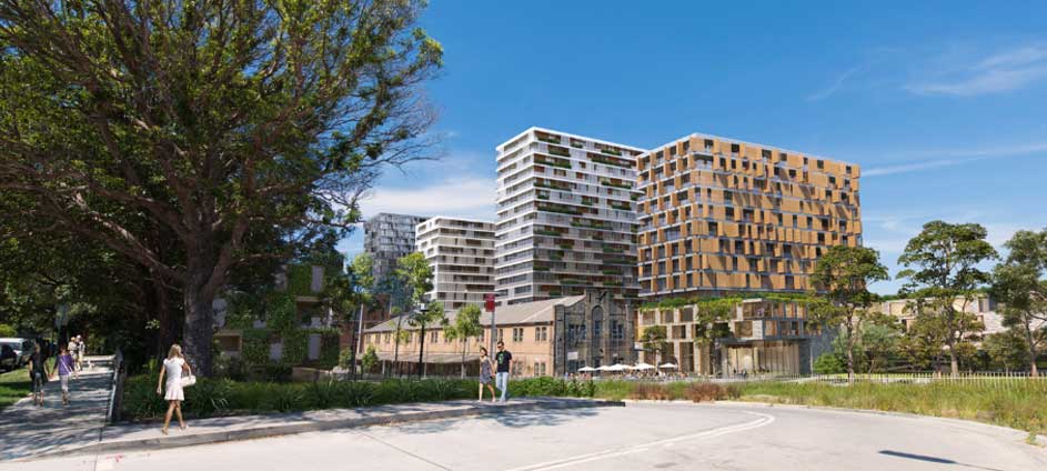
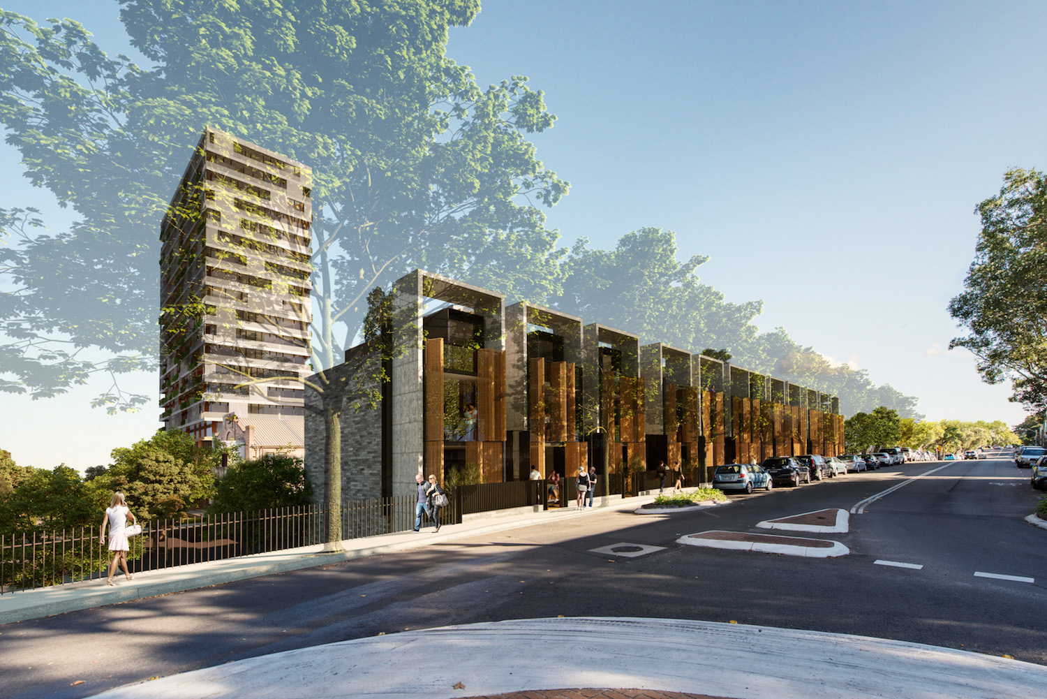
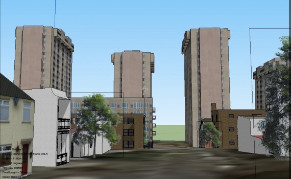
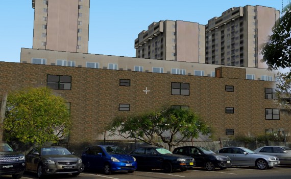
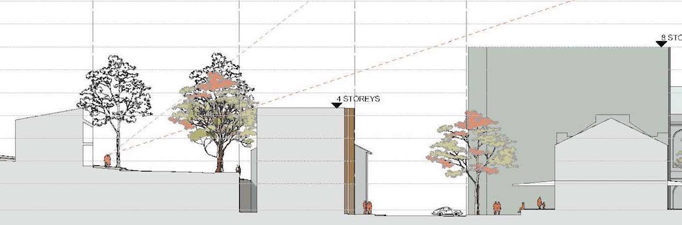
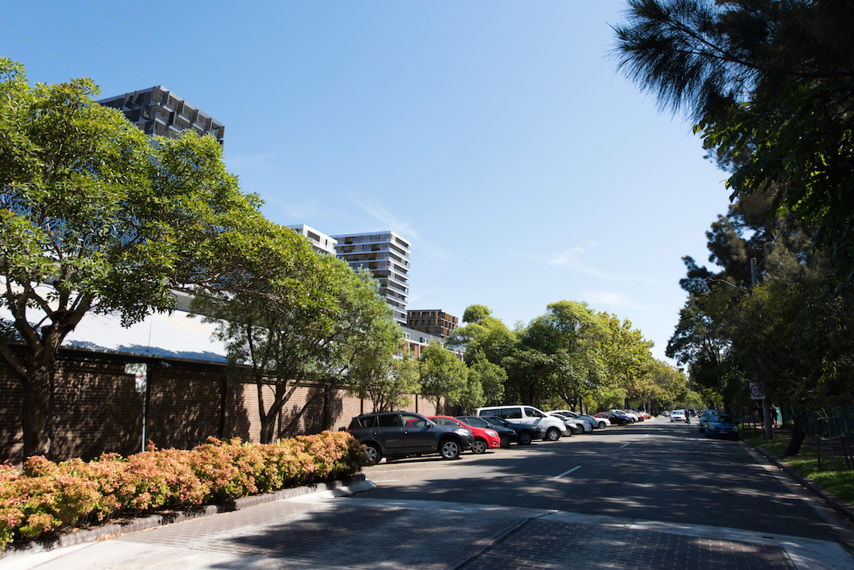
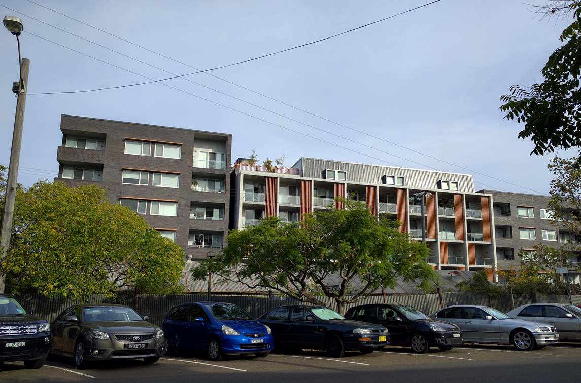
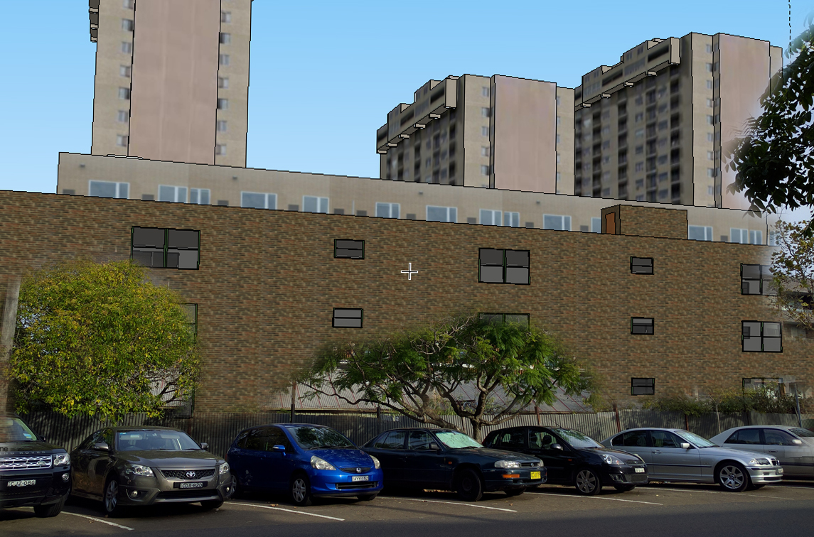
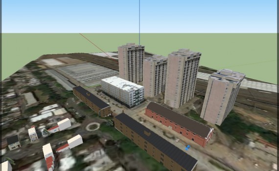
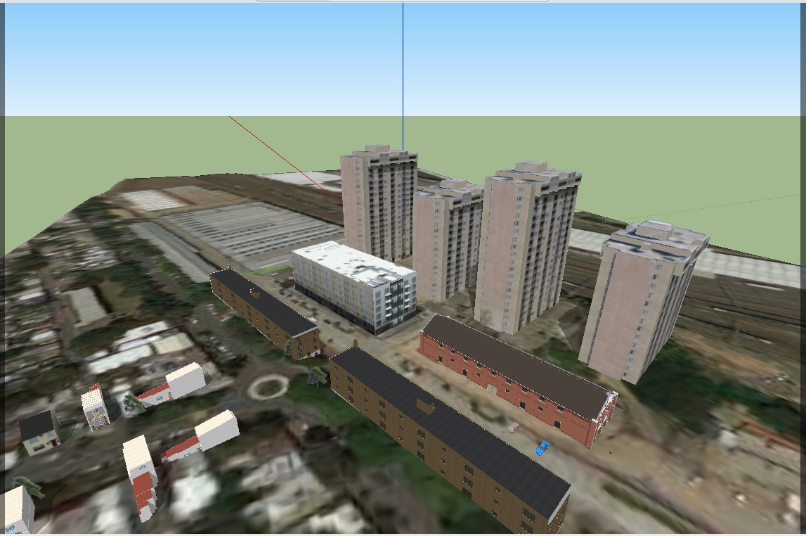
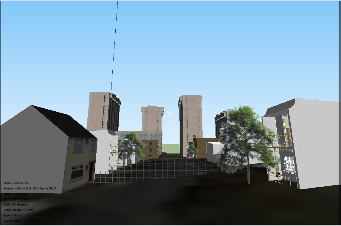
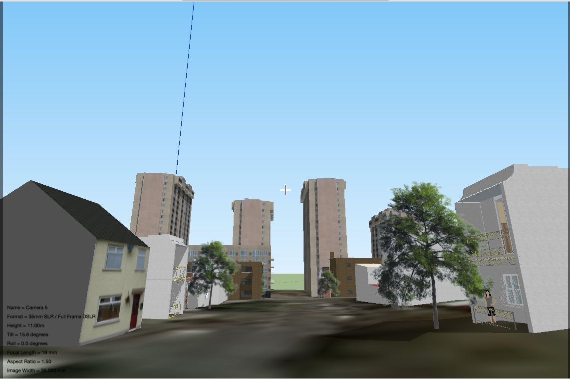
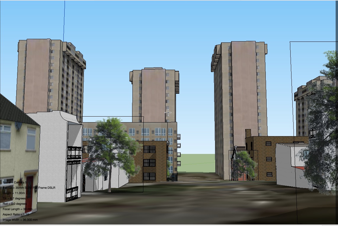
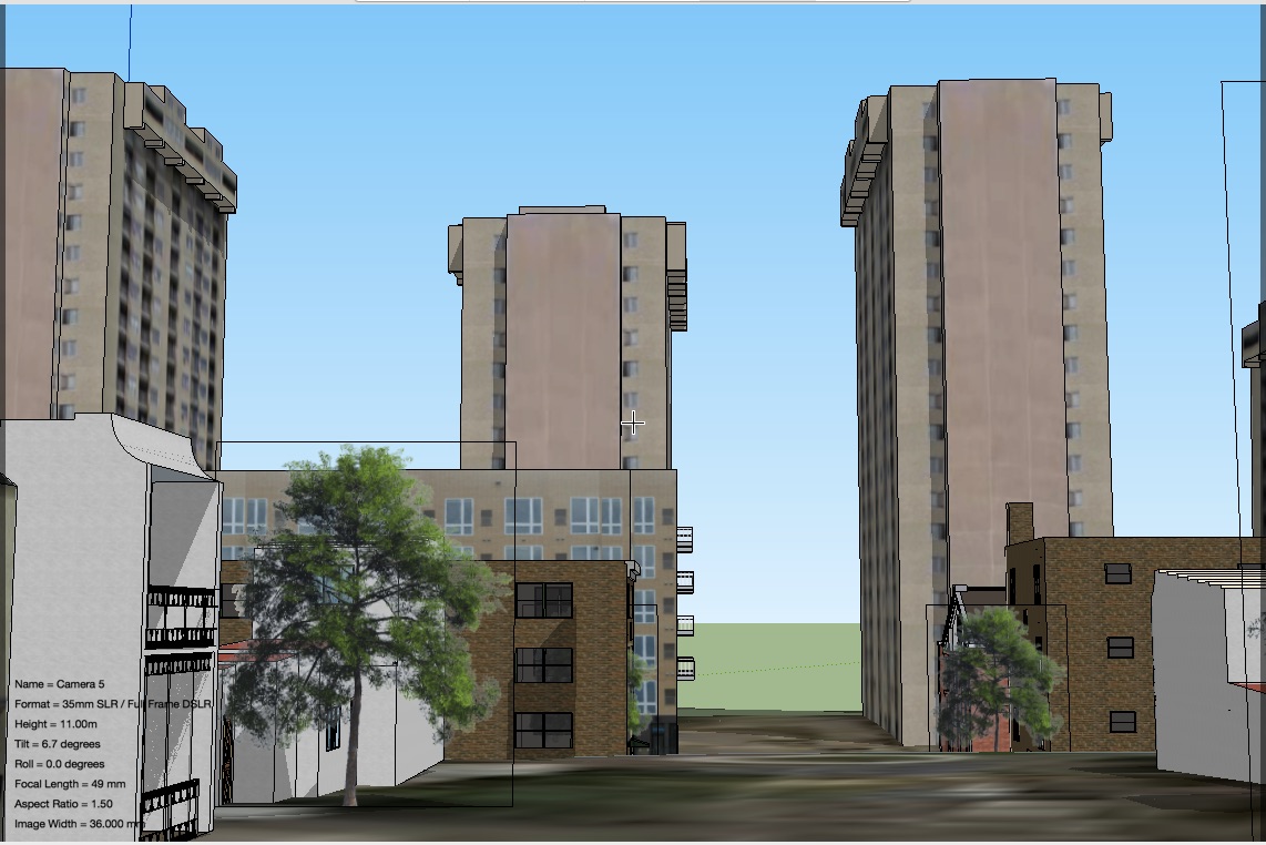
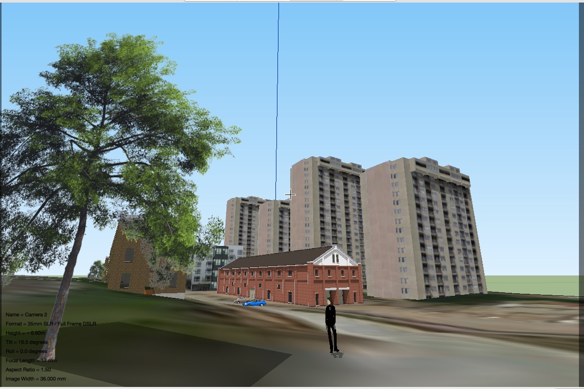
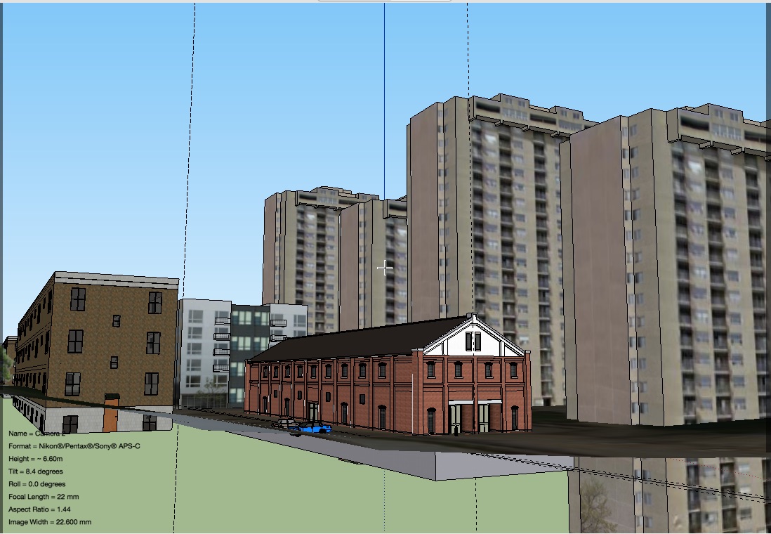
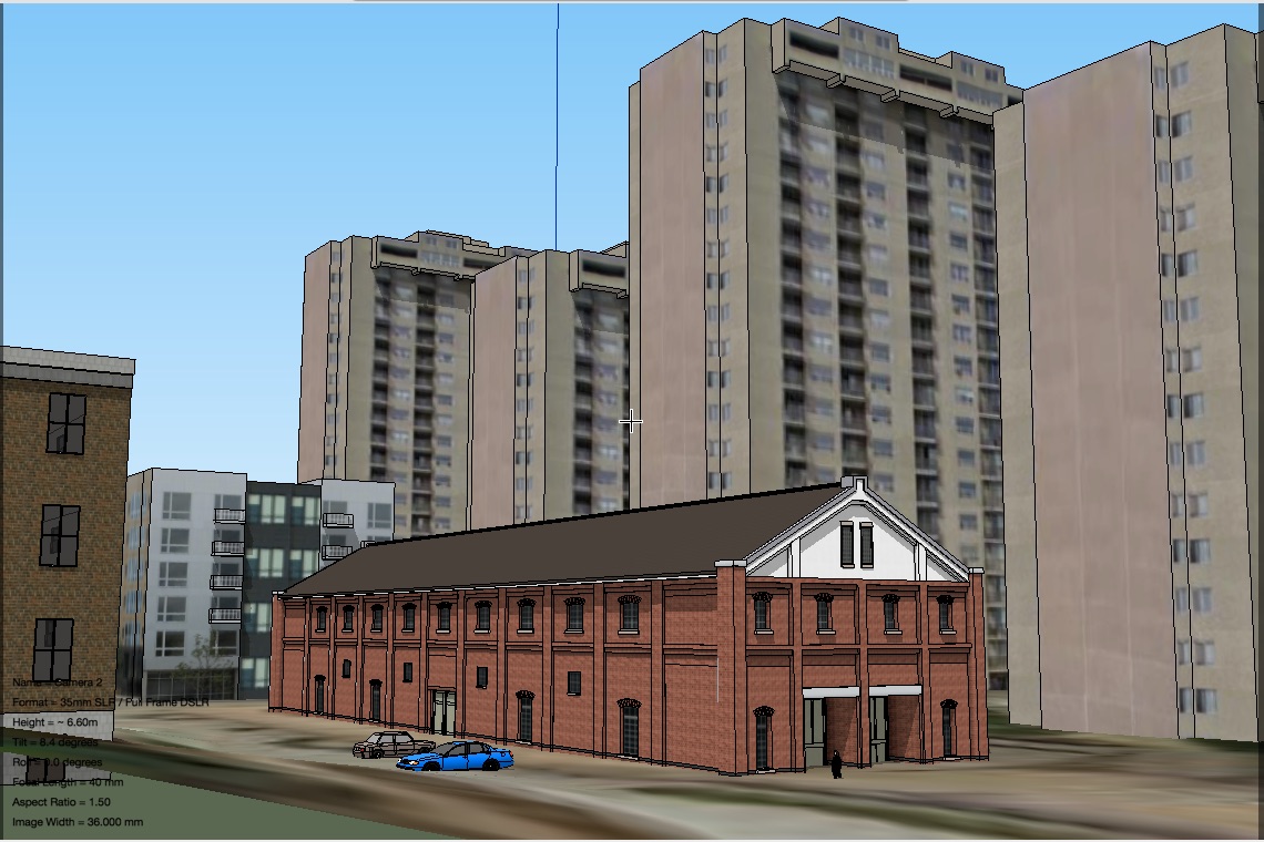
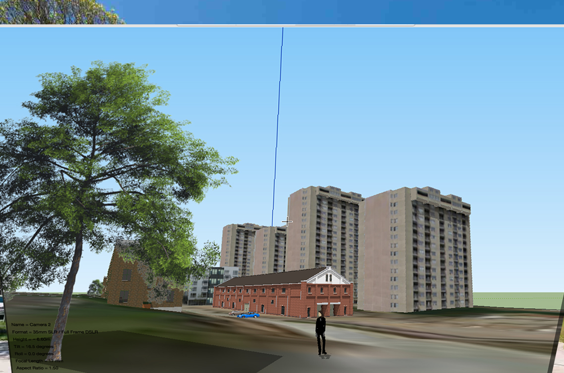
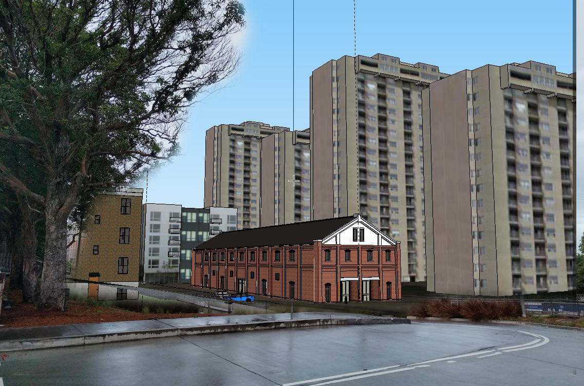
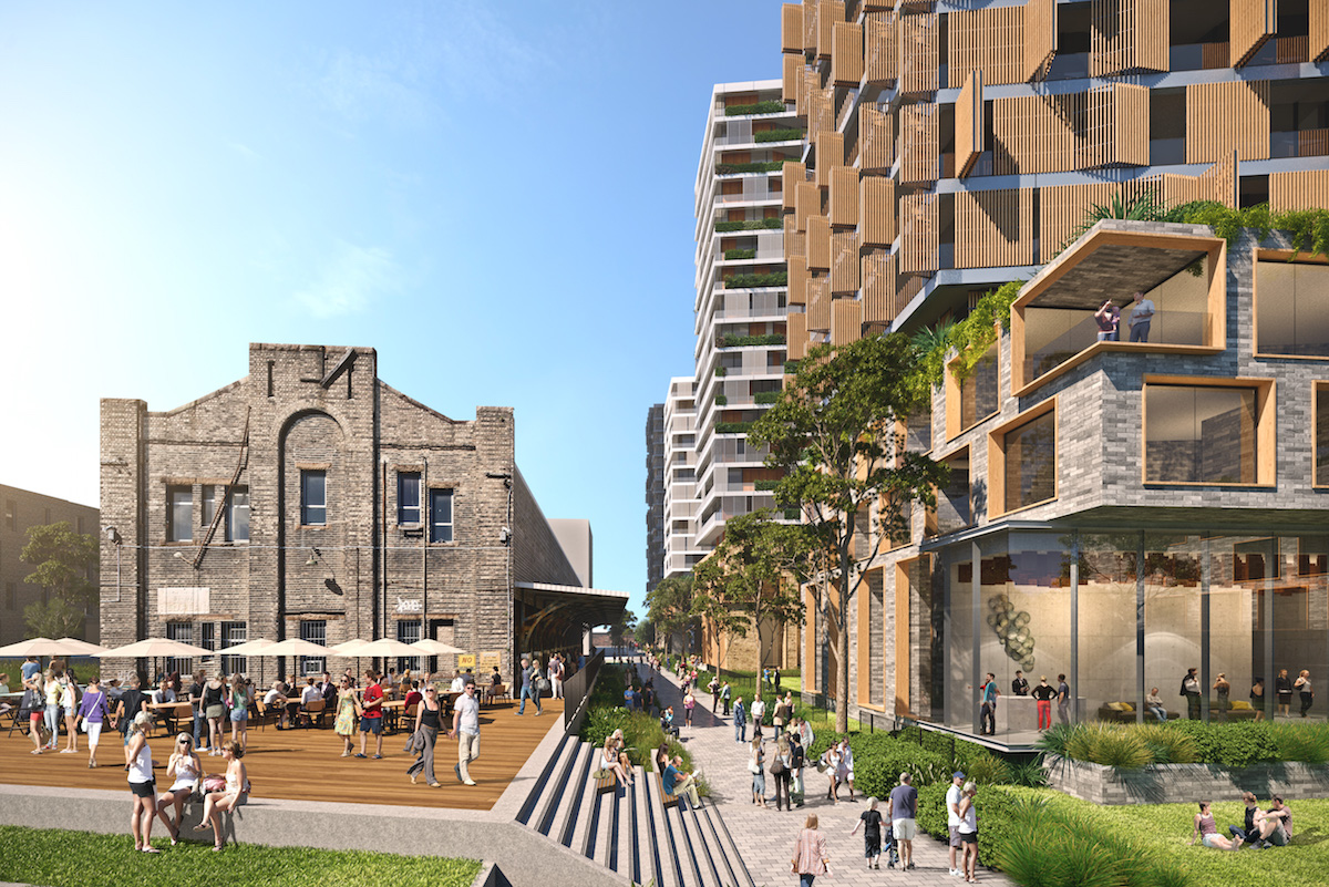
We are proposing 710 additional apartments at North Eveleigh, with building heights of between three and 20 storeys. The highest buildings will be located at the rear of the site against the rail corridor, with the lowest building heights closest to Iverys Lane and on Wilson Street.
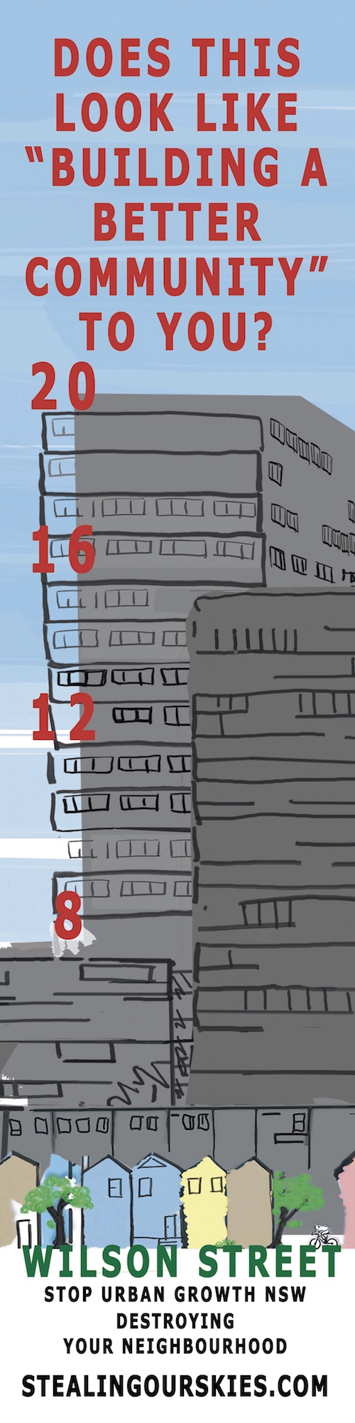
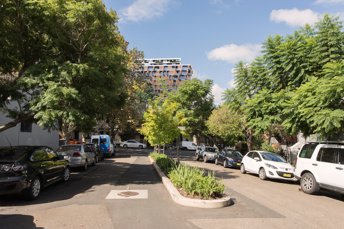
Undeniably, buildings up to 20 storeys in North Eveleigh will have a visual impact – they will affect the outlook for neighbouring residents and will be visible from some distance. However, given the need to balance metropolitan growth pressures with local amenity impacts we believe that the proposed density and mix of building heights is worth considering.
Q: Why are you planning for 20 storey maximum building heights and why do you think these are appropriate next to a conservation area?
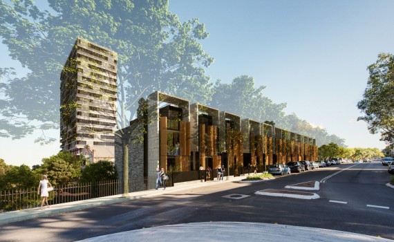
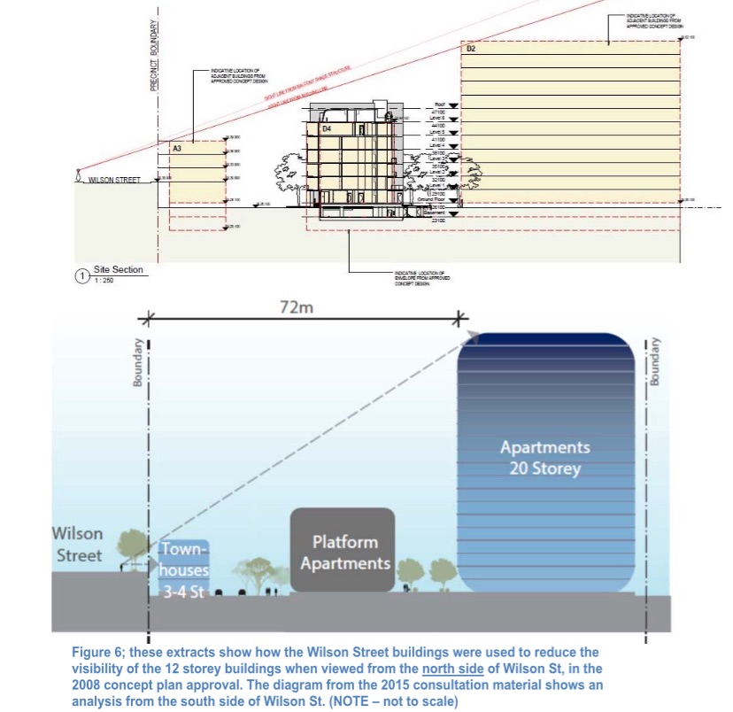
A: The plans respond to the heritage conservation area by locating higher buildings next to the railway corridor where they will have least impact, with lower heights closer to existing properties.
We are proposing a mix of building heights with two taller 20 storey buildings next to the railway corridor where they will have minimal impact on adjoining properties in terms of sunlight and privacy. Building heights then drop down towards existing properties along Wilson Street and Iverys Lane to respect the existing character of the neighbourhood.
This is consistent with our http://www.centraltoeveleigh.com.au/index.php?cID=236 Key Move 9 , to integrate new high density mixed use buildings with the surrounding area.
Heritage will be represented through the design of the park which will include public art. We also want to create a new hub for community interaction by restoring and adaptively re-using the Clothing Store building as a new community facility.
Q: Do you have a housing target? And if you don’t, how did you come to the number of apartments?
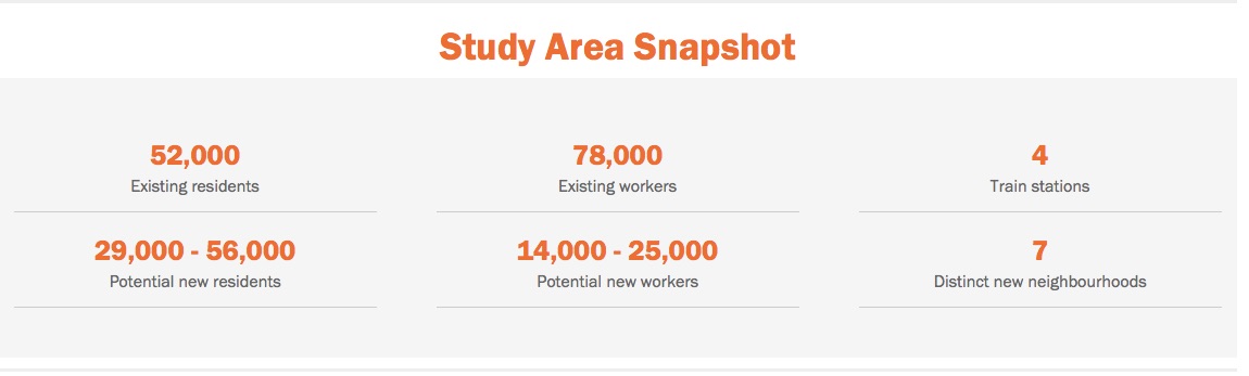
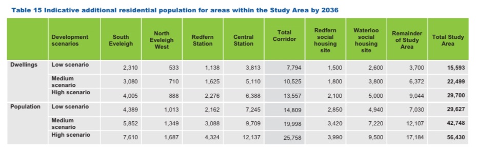
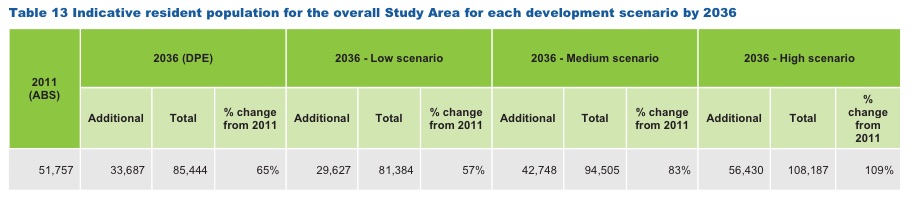
A: There is no target for the number of new apartments or residents. We used population scenarios of between 15,000 and 26,000 new residents in the corridor and between 29,000 and 56,000 new residents in the wider study area to test possible impacts of population growth on infrastructure and community facilities.
Outcomes from this analysis have been considered alongside expert studies and best-practice design principles to assess the level of growth we believe could be achieved in the corridor. Our focus is on making the most of opportunities to deliver new housing and jobs in a way that improves the liveability of the area for new and existing residents.
Our approach is to optimise development outcomes within the limits of good design. This means we will be pursuing medium and high rise buildings to provide as many homes and jobs as possible on sites that can be developed without overly impacting the amenity of adjoining properties and where development can be balanced with public benefits – including new community facilities and parks for the whole community to enjoy.
Q: Are you also planning to upgrade local transport, schools and health services, parks and community facilities?
A: Yes. We are working closely with other NSW Government agencies such as Transport for NSW, the Department of Education and Training, NSW Health and public utilities on the plans for North Eveleigh to ensure local infrastructure can respond to more people living and working in the area.
As confirmed by the Minister for Planning when announcing the sale of the Australian Technology Park, the revenue generated from development and public land sales will be reinvested in the local area to help finance major infrastructure improvements, including renewal of Redfern Station.
The Urban Transformation Strategy will identify the key infrastructure required to support growth and the long term funding requirements to deliver infrastructure upgrades.
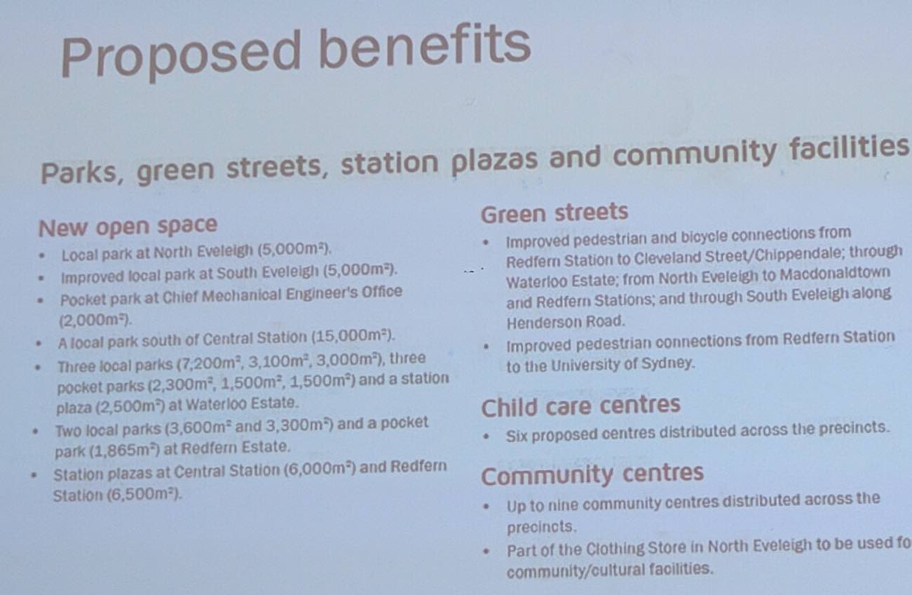
As part of North Eveleigh, we’re making provision for a child care centre on site and also proposing a new facility for creative community uses at the Clothing Store in addition to a new neighbourhood park.
Q: How many car parking spaces will be provided at North Eveleigh and how will you manage street parking in surrounding areas?
A: Our goal is for new developments in the Central to Eveleigh area to encourage the trend of reduced car ownership with more people choosing to use public transport or walk and cycle to get around. Promoting a reduced car dependency also reduces carbon emissions and promotes healthy lifestyles.
We are proposing 530 basement car parking spaces, which includes the existing 39 spaces at the Platform Apartments. This is the maximum number of spaces allowed under the City of Sydney’s controls.
We know there is a mix of views about parking; some people favour additional car parking spaces in new developments and others believe this will only encourage increased car usage.
There is a high rate of car-share use in the area. While some apartments won’t have a dedicated car space, car share schemes will mean that all residents can access a car when they need to.
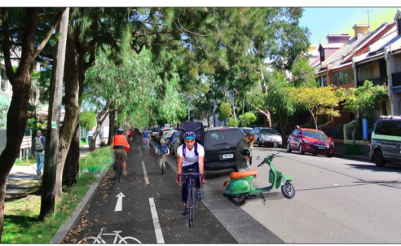
New residents will also be able to easily access public transport services at Redfern and Macdonaldtown stations and on King Street in Newtown. Future pedestrian and cycle links across the rail corridor and improved cycleways and pedestrian paths will create new links across the site and will also help to reduce car use and traffic.
The City of Sydney does not permit residents living in new apartments to get parking permits. Therefore, new residents will not be able to park in surrounding streets for extended periods of time without the risk of parking penalties.
Q: Will North Eveleigh have affordable housing and what percentage will it be?
A: Yes. At North Eveleigh we supported delivery of the Platform Apartments; 88 Affordable Housing apartments completed in March 2015 that are managed by City West Housing. With plans for an additional 710 apartments in the neighbourhood, this means that 11% of all housing at North Eveleigh will be classified as Affordable Housing.
Q: How can the Minister for Planning assess this proposal when he is also UrbanGrowth NSW’s Minister?
A: The development proposal for North Eveleigh will be considered as State Significant Development, which requires the Minister to determine the proposal, as set out in the <em>Environmental Planning and Assessment Act 1979</em>. While UrbanGrowth NSW reports to the Minister, there are clear guidelines set out in the Act that must be followed to assess the proposal, including formal public exhibition and a call for submissions once the proposal has been lodged.
Q: How did you promote the North Eveleigh workshop held on 12 November?
A: The workshop was promoted through a mix of methods including a letterbox drop to 41,000 properties in the area. Our distributor uses GPS trackers to ensure delivery to all properties in the area. We also sent 500 individual letters to randomly selected households, distributed an electronic newsletter to more than 1,600 people who have signed-up to receive project updates, placed advertisements in five local newspapers and promoted the workshop on the project website, Facebook and Twitter and at our monthly stalls at the Carriageworks Farmers Market and Redfern Markets.
Q: How will you report back and continue to engage the community?
A: Community feedback from the workshop, online discussion forum, social media channels, emails, letters and community markets, will be considered to refine plans for North Eveleigh.
We will publish a report that summarises the feedback received at the workshop on 12 November to provide a transparent record of community concerns and issues related to the development proposal.
We will undertake further consultation to shape plans before finalising a proposal that will be placed on exhibition in mid 2016. More consultation will be undertaken in early 2016 and will include another workshop, a drop-in display and discuss session, some focus groups and an updated online forum.
The development proposal will include a report detailing all feedback received.
Q: What additional traffic is your modelling showing, and how will this be managed?
A: Traffic consultant Parsons Brinkerhoff is updating a traffic model to test the impact of traffic associated with development at North Eveleigh on the local road network. Preliminary study results indicate that the development will not have a big impact on the local area, with the maximum forecast for an extra 100 trips per hour during morning and afternoon peak travel times. The local road network has the capacity to accommodate this volume of additional traffic.
The City of Sydney has a trend of decreasing car use per person. The proximity of North Eveleigh to rail and bus transport supports the trend towards reduced car dependence and we aim to encourage this trend by promoting public and active transport and car-share schemes.
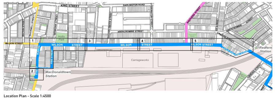
Q: There is only one entry/exit at the site to Wilson Street proposed. Will this be safe and how will this be managed with the number of cars expected to be entering and exiting the site?
A: There is currently only one access point to the site, however at least one additional access point will be constructed when the North Eveleigh East area is developed. The existing access has been designed in accordance with City of Sydney requirements and our traffic engineers will review the existing access arrangement as part of our development proposal. The preliminary traffic study indicates an additional 100 vehicles per hour will enter or exit the site at busiest times (during peak hour). Further reports are being commissioned as part of the development proposal to advise on traffic impacts.
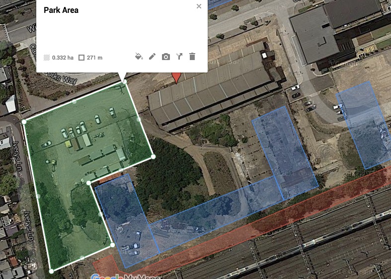
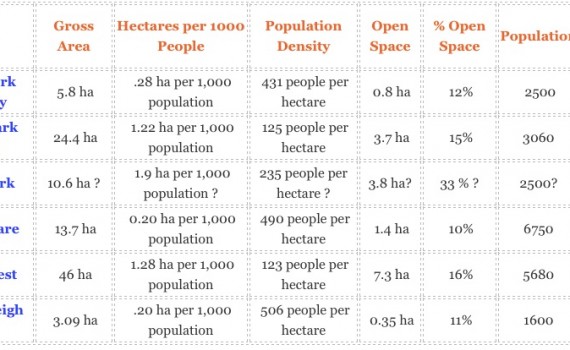
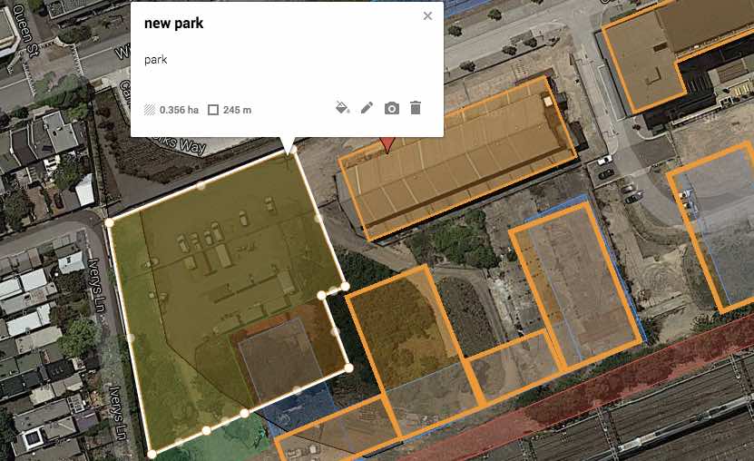
Q: Why can’t the park be bigger?
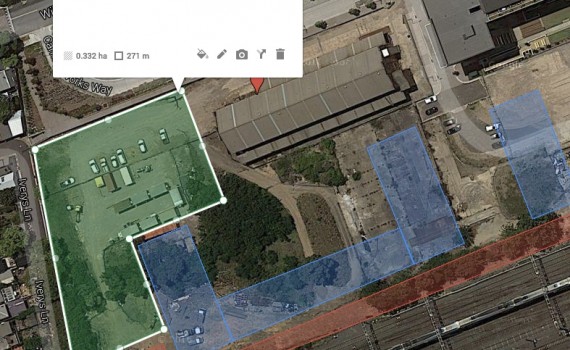
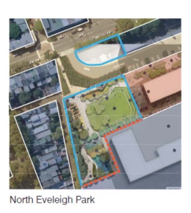
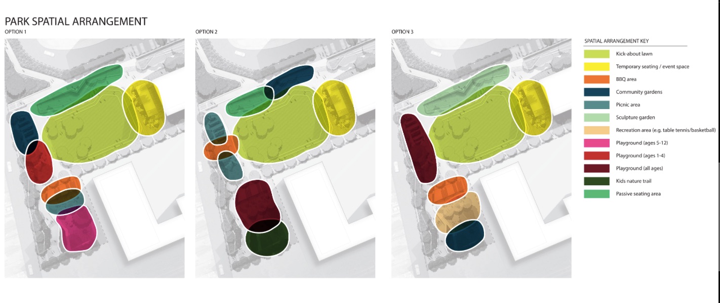
A: The proposed park is 4,479 sqm . The size of the new park has been increased by more than 1,000 sqm from the original design by changing the layout of buildings and internal roads. We believe the current design is the optimal balance between open space and well spaced buildings, respecting Clothing Store curtilage, creating through-site links and minimising overshadowing. The park will include a children’s play area, large kick about space and barbeque facilities for community use. Increasing the size of the park further would mean reducing building separation and potentially increasing heights, which would not deliver the best design outcome for the site.
Q: How can you say the development space has only increased by 20% when building heights appear to have more than doubled?
A: Although maximum building heights have increased from 12 to 20 storeys, the total development floor space has only increased by around 20% compared to what was approved as part of the 2008 Concept Plan. Previously, development floor space was approximately 50,000m<sup>2</sup> and is now approximately 62,500m<sup>2</sup>.
This has been achieved by designing taller buildings with smaller footprints to maximise publically accessible space through the site.
The development floor space in the 2008 Concept Plan was all residential, we are now proposing some retail and community uses as part of the revised proposal which is included in the proposed 62,500m<sup>2</sup> of floor space.
Q: What assurances can you give us of the quality of design and construction?
A: We have a long history of delivering design excellence in our projects, and the design principles will guide planning for new development across the area to ensure buildings are well designed and contribute to the creation of highly liveable neighbourhoods.
The planning system in NSW has measures in place to ensure quality design through initiatives such as the SEPP 65 policy for the design quality of residential apartment buildings and through the Building Code of Australia, which sets the provisions for the design and construction of buildings. We will also be guided by the City of Sydney’s approach to achieving design excellence.
In addition to this we are exploring opportunities to require design competitions for new buildings on the site to drive design innovation and excellence.
Q: How will this affect future connections with South Eveleigh? Where is the promised bridge?
A: We know it is important to create connections across the railway corridor, with design that will allow for future pedestrian and cycle links potentially to the Australian Technology Park and South Eveleigh.
The Urban Transformation Strategy will establish the preferred locations for new crossings. A crossing close to the Australian Technology Parkto is likely to be built within the next five to 10 years once development plans around Redfern Station and/or South Eveleigh have been approved. Timing for a crossing is difficult to confirm due to the complexities of construction over the rail line and the need for works to coincide with any above or adjacent development.
The park design allows for a potential walk/bike future crossing from North Eveleigh to South Eveleigh.
Q: With the large increase in foot traffic to and from Redfern Station, how will you make sure Wilson Street is safe?
A: The proposed North Eveleigh development will create buildings fronting onto the street which will provide more active frontages and passive surveillance along Wilson Street. People walking to and from the site will result in increased foot traffic and activation of Wilson Street. Busier pedestrian areas are generally considered to be safer.
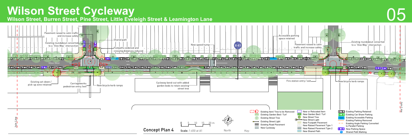
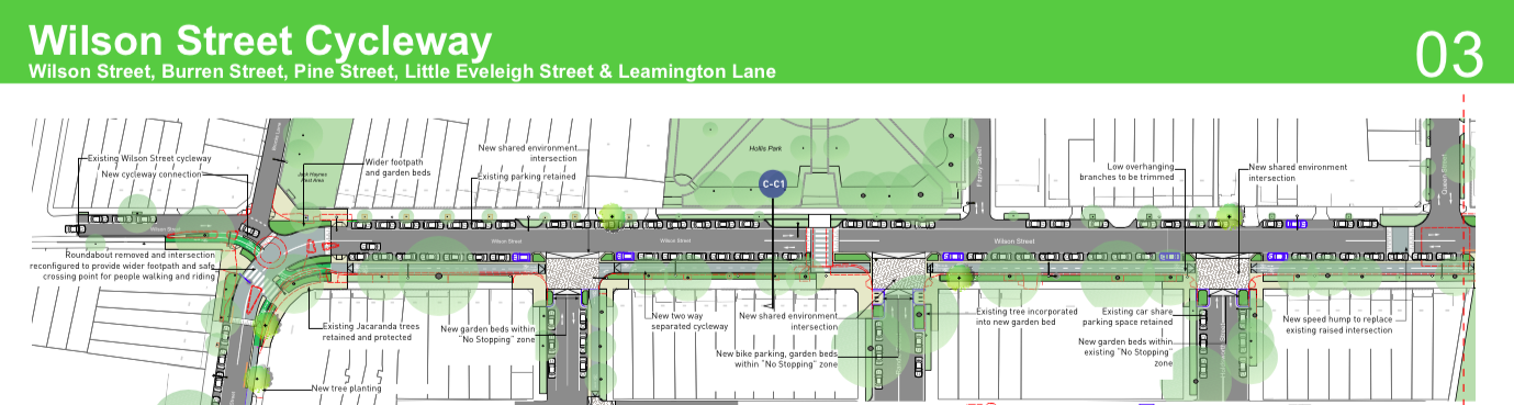
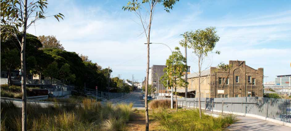
As part of http://www.centraltoeveleigh.com.au/index.php?cID=236 Key Move 2, Wilson Street will be part of a ‘green network’ which means it will be tailored for increased pedestrian and bike use. Pedestrians will use the footpath, separate to cyclists and cars. The footpath on Wilson Street has minimal driveways, which means that it is already a safe pedestrian area.
Q: When will Iverys Lane steps be opened?
A: Access to the stairs to Iverys Lane is currently restricted while we undertake additional work to improve pedestrian safety. This includes: </p><ul><li>appointing a road safety auditor to review the location of the stairs and any additional measures to improve safety</li><li>preparing a concept design for a shared zone in Wilson Lane </li><li>obtaining endorsement from the City of Sydney’s Local Pedestrian, Cycling and Traffic Calming Committee and agreement for the shared way to proceed. </li></ul><p>We hope to construct the shared way in 2016 after which we can open the stairs for public access.
Q: How will you manage basic utility services, for example won’t there need to be an additional 800 garbage bins collected from one narrow street?
A: The traffic study being done to inform planning for the site includes analysis of how to adequately service the site for garbage collection and other services.
We are developing the Urban Transformation Strategy that will guide future development in the short, medium and long term while the City of Sydney will retain responsibility for providing municipal services to the area, such as rubbish collection. We meet regularly with the City of Sydney to ensure they are involved in the early planning of the area. There are no foreseeable issues with having a weekly garbage collection service the site.
Q: Why has our opposition to height been ignored?
A: All feedback from the community is carefully considered in our planning. It is our job to consider the trade offs associated with the benefits and impacts of new development on the city and the local area.
We have been consulting with the community for more than two years to develop a <a href=”http://www.centraltoeveleigh.com.au/index.php?cID=236″>vision, design principles and the 10 key moves</a> to ensure that we deliver balanced outcomes at metropolitan, inner city and local neighbourhood levels. Feedback indicates that there is broad support for the vison, key moves and design principles. </p><p>There are mixed views about height and density. Some people are strongly opposed to high rise buildings, but many others have told us they can accept tall buildings and high density development as long as we ensure design excellence, variety and innovation and deliver in line with the design principles. </p><p>Our consultation focus is, and always has been, about how we plan and deliver medium and high density development to provide homes and jobs in a way that ensures the area remains a highly desirable place to live, work and visit.
Q: Will there be overshadowing and what impact will it have (including from 8am)?
A: All high rise development casts long shadows, but the impact of the shadows can be minimised through good design. The proposed building layout at North Eveleigh seeks to minimise overshadowing of neighbouring properties and the park by putting taller buildings on the southern boundary near the rail line so that shadows fall primarily into the rail corridor.
<a href=”http://www.centraltoeveleigh.com.au/index.php?cID=356″>Shadow diagrams</a> have been prepared in accordance with industry standards to show the impacts of overshadowing at key times of the day in mid-winter, when there is the least amount of sunlight, including 9am, 11am, 1pm and at 3pm. They show that at these times the proposed buildings will not overshadow the habitable areas of existing houses and will have minimal impact on the park.
The 8am mid-winter <a href=”http://www.centraltoeveleigh.com.au/index.php?cID=356″>shadow diagram</a> shows more extensive shadowing to the park and houses backing onto Iverys Lane. However, this shadowing has largely gone by 9am as the sun rises. </p><p>The <a href=”http://www.centraltoeveleigh.com.au/index.php?cID=356″>shadow diagrams</a> show that the park will be in full sun for most of the day, which exceeds the City of Sydney’s requirements for only half the park to get direct sunlight for four hours between 9am and 3pm.

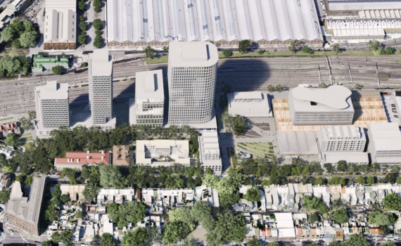
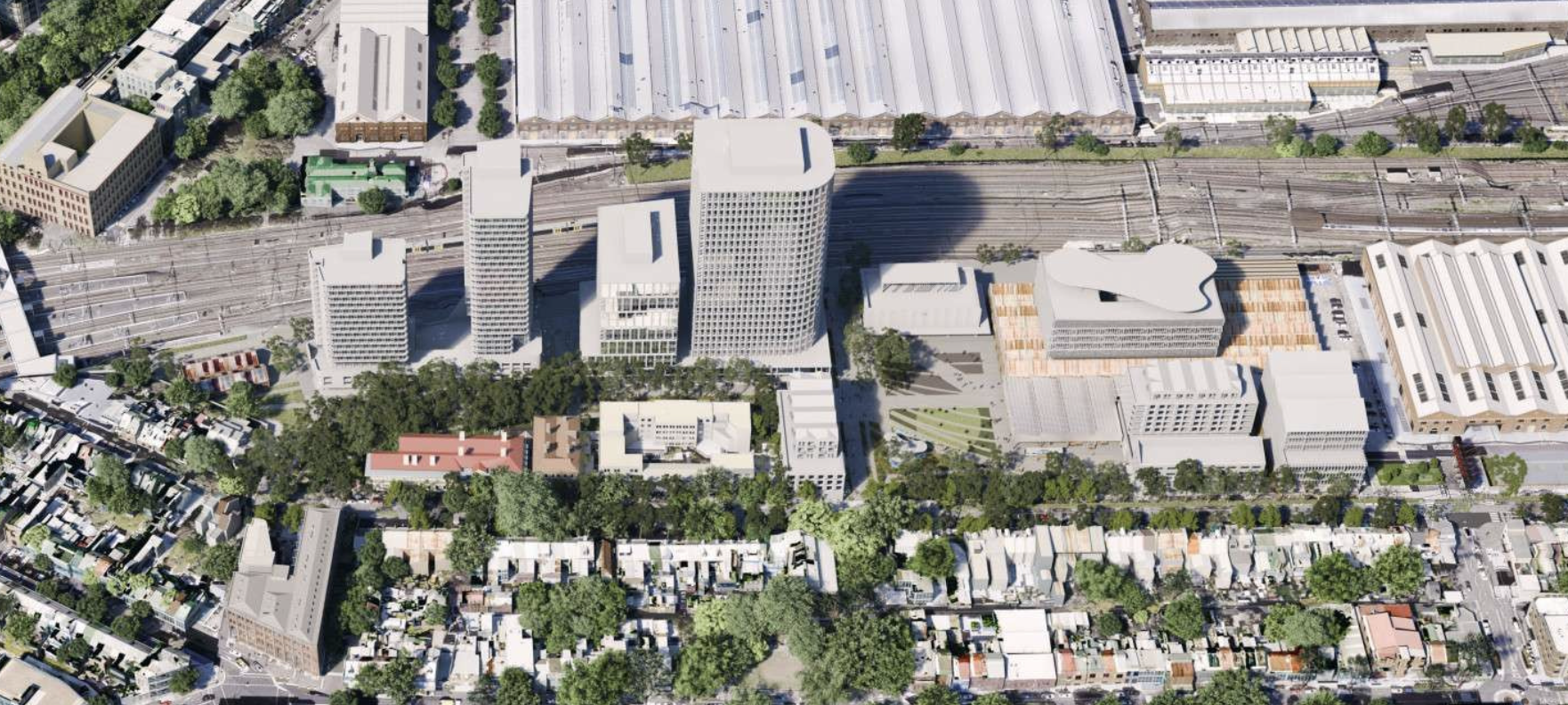 Submissions due this Thursday 25 August for the Redfern North Eveleigh Paint Shop Precinct rezoning proposal. The results of this proposal will obviously have dangerous consequences for the North Eveleigh Site which we have seen go from 12 Storeys 2008, 20 Storeys 2016 and now 28 Storeys 2022.
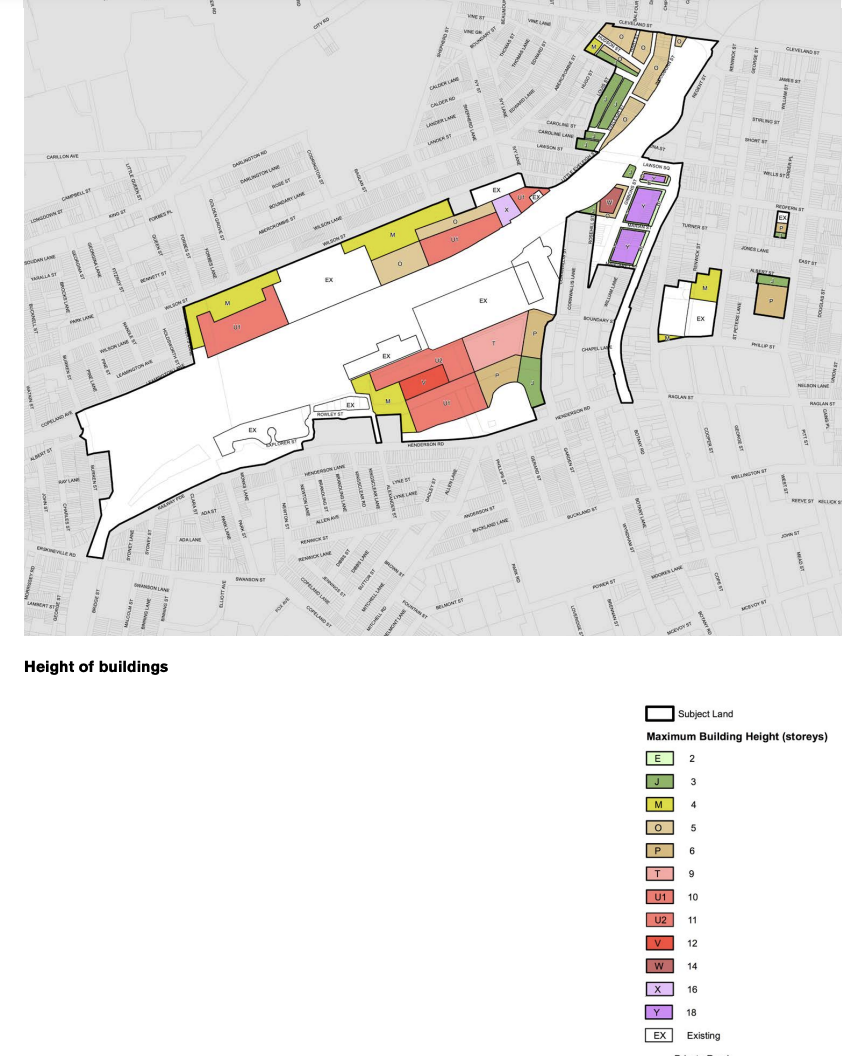


 NOTE 1 – “The City of Sydney is updating the Open Space & Recreation Needs Strategy 2006 and reviewing its Section 94 Contributions Plan 2006. The Council recently resolved that the Open Space, Sports and Recreation Needs Study will be prepared by the end of 2015” (page 81)